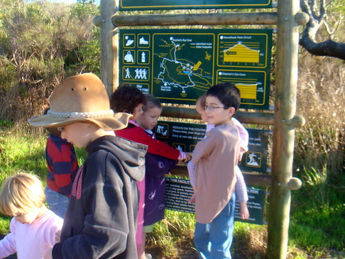
We are wandering our way through a homeschool series and covering topics that we covered for school this past school year, one topic at a time. When I asked our readers if that had any specific topics they would like to cover there were heaps of them… and they looked like this: Map work and art appreciation; map work and writing; map work and reading… So while everyone wanted different topics the one overriding theme that everyone really wanted to know about was Map Work.
Funny thing is until this year map work really was the one topic that caused me the most guilt!!! I had this idea that real home schoolers has a huge map on the wall alongside where they did school and that real home schoolers would pin all sorts of interesting things onto their maps… And not only that but each student would have a huge fold out map with magic markers for plotting their educational journey… Well clearly we weren’t real home schoolers – because there was none of that. And each the our curriculum notes said: map activity I would say, lets do it next week, next month, next year – well really never!!!
Now the purpose of maps as a teaching tool is surely so that we can least about the great wide world and also about locating things and determining where events occurred and so on. I have no problem with the reason for studying maps and in fact the more I thought about it, with our heap of Geography resources at hand we were really doing World Exploration. In fact, we love traveling virtually and in the real world, getting to know about places far and wide. So clearly we had a purpose for studying maps, but no strategy. And I had to figure this out as well: You don’t have to have a giant wall map and each child does not have to have a giant smudgy mark-it map, that the pens skid over and little hands unintentionally wipe off the most important facts that should have been saved…
So we needed a map work strategy for our five day school week…
- A large Coloring Map:
- Geography Songs:
- A Great Kids Atlas:
- Journal Maps:
- Bible Maps:
- Travel Guides:
- Road Trips:
- Maps Just for Fun:
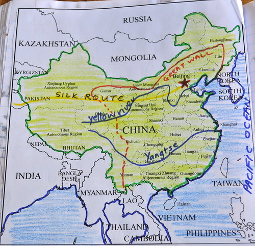
We got a large coloring map and once a week we got together and marked on the map the countries of the world we had read about that week. This year we read through the Window on the World at breakfast time most mornings, so once a week we had a couple of countries to color. One map that we kept folded up most of the time… But when we opened it up it was simply amazing what everyone had learnt!!! This map comes with the Geography Song Book from Sonlight (mentioned below), and you can buy extra copies of the map for extra students.
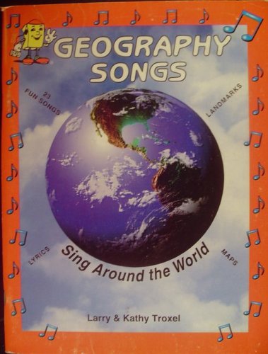
I know this is a good product, we have had it as part of our curriculum, A CD of catchy, easy to learn songs of countries of the world and a coloring/work book to help you place the names you have learnt. Honestly, we have never got past the first couple of weeks before we quit it and put it away. The CD we listen to a couple of times and learn the songs instantly, but the coloring book… well we never get to it and so no-one was learning where any of the places were. Not much point in knowing the countries of the Middle East if you have no idea where each country is. I needed to spice our Geography songs up… way up!!! This led to the next point:
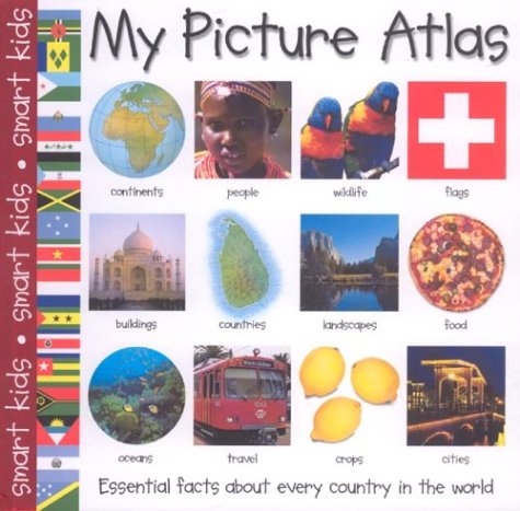
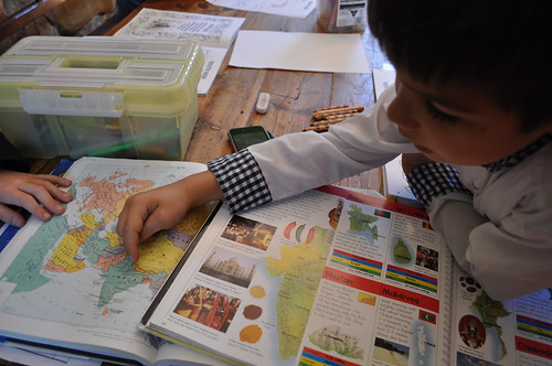
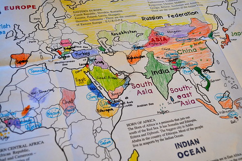
Now there are any number of great kids atlases on the market, and we have a couple but we needed one that had a little info on each country… This Picture Atlas was perfect for us: We learnt how to say hello in their language; what their favorite food is; what their flag looked like and so on… just making the countries a reality as we stepped through them. We read about a country, colored it and then on to the next country… at the end of a page of coloring we had a quick quiz. Everybody loved it and for the first time ever we got through our Geography song book… It just needed a little spark of interest to bring us back again and again.
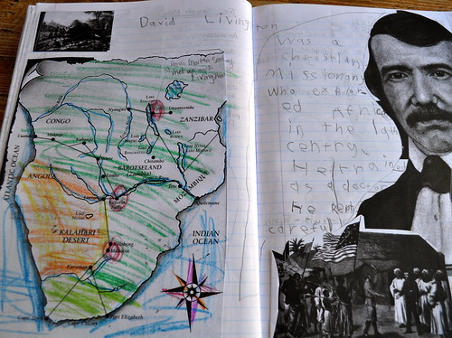
My kids use journals for their history notes and instead of ignoring the map work suggestions in the teachers guide this year, we took the maps provided in the instructors guides, for each book, and used them to help us tell our history stories in our journals. As I read we would mark the spots on the map and discover and see where we were learning about.
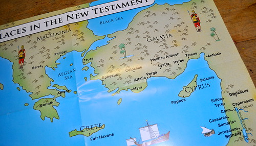
Since this was the year to get maps and mapping under our belts we decided that it was a good time to figure out all those maps at the back of our Bibles. You know those maps that you look at during the sermon on a Sunday morning… So we got this fabulous pack of wall maps and popped a fresh map on the fridge every couple of weeks. The pack came with a short explanation and printable maps for coloring and popping into our journals.
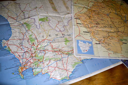
We got a couple of travel guides out of the library and read about other cities of the world and their maps too. For instance, when our grade 1 student got stuck into Rome we had great fun plotting a trip on a map of Rome – plotting whose famous arches to see on a walking tour, and a visit to the Pantheon while eating gelato. We traveled through a couple of cities in Europe like this and will definitely be taking more travel guides out of the library in the future.
We needed to learn how to use maps and while a cross-continental trip would be lovely… you can also just get out a map of your local area and ask your kids to plot and plan their daily/weekly routes.
And finally…
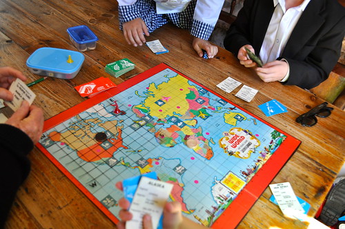
We were able to include a couple of puzzles and board games that have maps as part of the game… they were fun and an easy way to learn about places around the world – there is no better way to learn than by playing.
By the end of the year our students could present a passable map in their journal and use it to demonstrate that they hard learnt about a person or an event… I think the lesson was learnt and I think throughout our school year map work became more and more a visual way of presenting their work and a tool that they can take with them. Did we learn every country and every capital… No!!! But we all know a whole lot more than we did at the beginning of our school year and we had a lot of fun doing it!!!

Thank you! This is great. 🙂 What is the name of the Bible maps, and where did you find them? We’ll be back to Geography Songs next year, and I may use the map that goes with that also. Good idea. Thanks, Lillian
Awesome post thank you!
We have an awesome geography map game called Brainbox The World (from Toys R Us) your guys would love it, each is a map card of a different country and it is a time trial to remember all the pictures of each country under a certain amount of time….mine love it! Love the bible maps that you have pictured here, never seen such lovely colourful ones. Where do you get your large colour in map, did you download it? We have also been downloading maps from enchanted learning to colour and answer quiz questions (occassionally) …. love your blog! love it love it love it!
Hi Lillian… I have blogged about the Bible Maps before – they are a fabulous resource that one of my kids spotted in the Christian Book Shop that sponsors us, “Christian Book Discounters.” They are published by CEP Youthworks and if I could give you a link I would, but the link goes – nowhere and the same thing happens when I google them. So if you can find a link that works let me know because all my comments asked about them!!! Hope you are having a fun weekend!!!
Oh Tammy, Your game sounds like fun!!! THe large color in map you can order from Sonlight… it comes with the geography songs CD but you can by it separately as well – the link is in the post. As I replied to Lilian, we found the Bible Maps at Christian Book discounters and we blogged about them earlier in the year… They have been a fantastic resource, we have had so much fun with them, I just can’t find an online place to order them. Thanks so much for your enthusiasm!!! Love that you love our blog!!!
Map work yay! We just started as well… And I think I learned the most! The game you mention looks amazing… What better way to do it? Love your blog.
so full of inspiration!!! I just got the geography songs in my sonlight box – can’t wait to try it!
Hay Carolyn, Oh I hope you have fun traveling the world – it is quite amazing how much there is to learn!!! Thanks so much for stopping by and I hope you have a fab week!!!
Oooh Leslie!!! A Sonlight Box!!! I am sure you guys will love the Geography Songs and before you know it you will all be humming away!!! I love reading about your work and your painting post was just fantastic… an amazing effort you guys are doing, well done to all of you!!! Hope you have a fantastic week!!!
Sorry this is coming in a little late but I have an author for you. You have probably heard of him, but if not- my family loves M. Sasek. He has done about 18 books on countries throughout the world all entitled “This is…” (fill in name of capitol city). Our favorites are Hong Kong, Australia, Cape Kennedy/Canaveral, and London. They were done in the 60s-70s and they are gorgeous! He drew and painted every city and its customs and cultures and he has a nice modern look to his art. The books are good for older readers to read (and funny) and great for little ones to pore over the pictures! They really bring the countries to life.
Hi Jaime, It is never too late for a fabulous comment!!! Thanks for the great tip… I read these as a child and I must dig them out to share with my kids, they were fabulous!!! Thanks for the great reminder!!! Hope you have a great week!!!